The Beginning
In the sixth year of my comfortable retirement, I was alarmed one morning during our sunrise jog when Garnie and I came over the hill to see the trees in the forest adjoining our property to the east being leveled. I ran out to stop the equipment operator to find out what was going on. His reply, “we have been hired to clear the land, I guess houses are going here, that’s what always happens.”
I ran back to the house and called the retired doctor land owner who lived in Fayetteville. He owned this land speculating on future growth, thus I feared the equipment operator was correct in his assessment. Weeks later, when Dr. Thompson returned from his vacation, I learned he had sold the land to a neighbor on Hutcheson Ferry Road who was putting in a pasture airstrip. The immediate threat of houses taking the place of the trees was over but we still lost the forest for an airstrip. As they dug the stumps and flattened the land for the landing strip, I kept fantasizing about the open gap in the forest becoming a wildflower meadow. (How the land eventually became a wildflower meadow is a story for another day. The disruption of the current waste water drip field expansion is mild compared to regrading the earth for the landing strip. Plus, we know the wildflowers will be restored.)
The vanishing forest on our eastern edge was an eruption to my daydreaming pastime in retirement and served as a wake up call that development could head our way at anytime.
Following the bulldozer encounter, the conversation about protecting our rural area started one morning in early 2000 with Rodney Peek and his parents Janice and Ned Peek at their kitchen table. Concern in the broader community about the future of our area was prompted by the leveling of trees on the west side of Palmetto changing the forest along Carlton Road into a barren view of stripped red clay. Fueling our fear even more was news that a 100 acre tract on Hutcheson Ferry between our homes and Palmetto was under contract with a builder planing to put 150 homes on the site. (This is now Hutcheson Ferry Park but that is also another story to tell.)
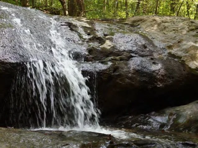
Following the conversation in the Peek’s kitchen, I called the various preservation groups for help, but their funds were all being deployed in front of bulldozers in the northern part of Metro Atlanta. I wondered who the large land owners were in our general area and what their plans were. One family, the Bouckaerts, owned 8,500 acres just north of us. Thus, Marie and I invited them to dinner. We discovered we had shared interests including seven teenage children between the two families. New friendships were started and conversations on the future of the area deepened. Mieke is a lover of the land and we had her support by the time we finished the first glass of wine. Carl agreed during following dinners that land values could increase if we found a way to balance preservation and development. With their support, I had hope. Our friendships continue to this day and all seven members of the next generation have families of their own. I never guessed that our interest in saving the land for future generations would lead to my actual grandchildren growing up on this land. While the Bouckarets are scattered across the globe, Marie and I are so lucky that our daughters brought their upstate New York husbands home and our grandchildren can play in the same fields, splash in the water fall and dig in the sandy stream bed just as their mothers did in their youth.
As we studied maps thinking about who else owned land in the area, we saw the defined area in the southwest corner of Fulton County that is bordered by Highway 154 on the east, the Fulton/Coweta county line on the south and the Chattahoochee River on the northwest side of the area creating a triangle shape of 40,000 acres. This area became our focus. Next I will remember more about how we organized a conversation with almost 500 neighbors.